The Reservoir Route in Gran Canaria is an ideal route for those who have a special interest in discovering new landscapes. Visiting these places means welcoming nature, beauty and disconnection. It is a perfect alternative if you are looking for something to do in Gran Canaria.
Where Is the Reservoir Route Located?
The Reservoir Route in Gran Canaria is located between the municipalities of Tejeda, Mogán and San Bartolomé de Tirajana. It crosses the Nublo Rural Park and the Pilancones Natural Park.
With a length of approximately 12.2 kilometres through trails, dirt tracks and asphalt roads, it is a circular route especially recommended for those with hiking experience. Therefore, you should not miss it if you are truly passionate about nature.
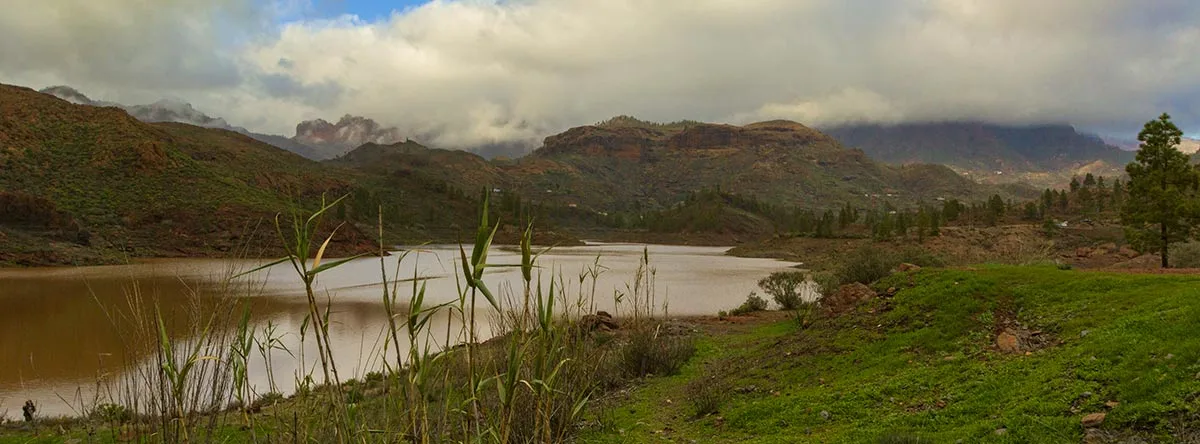
The route starts at Degollada de la Cruz Grande, where you will cross a wide pine forest before reaching the impressive Soria Reservoir, the largest on the entire island.
During this route, you will witness the spectacular volcanic formations found in the area of Cañada de Almajo.
What Not to Miss on the Reservoir Route in Gran Canaria
The Reservoir Route in Gran Canaria includes various monuments and natural landscapes, among which the traditional cave houses that are still preserved in excellent condition are worth highlighting. There is also a hostel where rural tourism activities are organised very close to Chira Reservoir.
In these majestic corners, you can connect with nature and enjoy this set of reservoirs of singular beauty, which manage and distribute water throughout the island.
In the area covered by the Reservoir Route in Gran Canaria, you can enjoy different activities such as rappelling, taking a kayak tour or swimming in the fresh waters of these reservoirs, in the areas where it is permitted.
The Best Reservoirs in Gran Canaria
There are 168 reservoirs in Gran Canaria, forming a recognised engineering work from the last century. They were created as a result of the need to obtain water for a growing population. However, today they no longer have the same use and are considered a kind of legacy in Gran Canaria.
Some of the reservoirs you should not miss on this hiking route in Gran Canaria are the following:
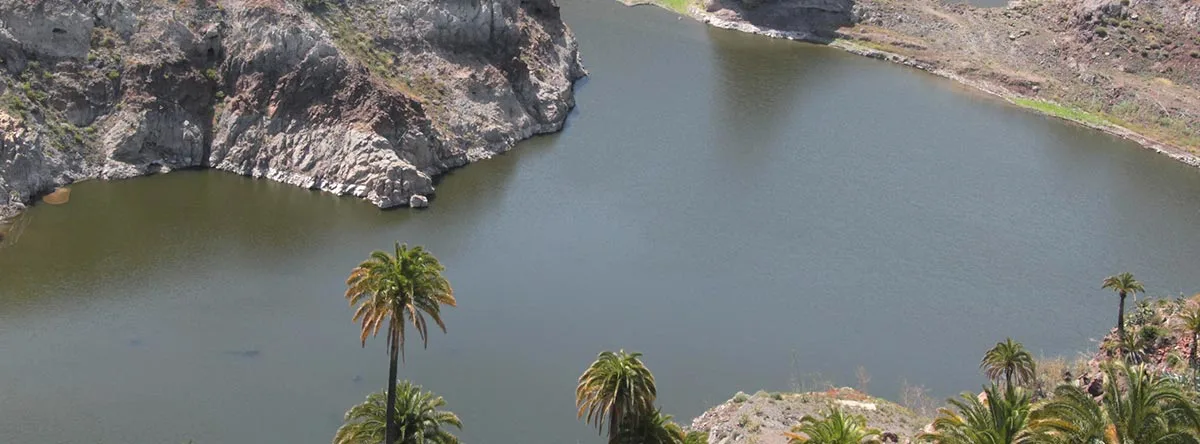
Chira Reservoir
On the Reservoir Route in Gran Canaria, you should stop at this reservoir, located at approximately 875 metres above sea level in its riverbed and 907 metres at its crown.
The reservoir is surrounded by pine trees, jarones, rockroses, yellow broom, black tajinaste and bitter tabaibas. In addition, when passing through this area, you can visit the village of Cercados de Araña, which will captivate you with its houses surrounded by palm trees and crops.
Soria Reservoir
This reservoir on the Reservoir Route in Gran Canaria is an engineering construction dating back to the 1960s and 1970s. It stands out for being the highest and largest reservoir on the island, with 32 hectometres that have not yet been filled.
Mulato Reservoir
This is one of the most important reservoirs in Mogán, used for agricultural activities.
It has a capacity of one cubic hectometre and offers a perfect landscape to disconnect, rest and let time pass. There, you can enjoy wonderful pine forests and forget about everyday routines.
Sorrueda Reservoir
This is a beautiful landscape setting that should be on your list of places to see in Gran Canaria. With unparalleled splendour, it is surrounded by ravines, mountains and a Canarian palm grove. It stands out for its tranquillity, partly because it is not a very well-known environment, and is considered one of the best-preserved places on the entire Reservoir Route in Gran Canaria.
If you have decided to do the Reservoir Route in Gran Canaria and stop at this place, you can also enjoy the Sorrueda Viewpoint, which hides beautiful views that are true proof that, in the municipality of San Bartolomé de Tirajana, not only the beaches are admirable, but it is a paradise in every possible dimension.
In addition, another of the most outstanding places on the Reservoir Route in Gran Canaria is the Fortaleza de Ansite, located about five minutes from Sorrueda Reservoir. It is one of the largest archaeological sites on the island. This is one of the places where the Canarian aborigines surrendered to the Castilian troops, which explains its historical importance.
Presa de las Niñas
If there is one thing that distinguishes this reservoir, it is that it is ideal for camping and connecting with nature. Here, you can enjoy a relaxing and renewing swim in its fresh waters.
It also has a base camp or starting point from which it is possible to follow different hiking routes.
Recommendations for Visiting the Reservoir Route in Gran Canaria
If you have decided to discover the Reservoir Route in Gran Canaria, we recommend taking the following tips into account:
- Bring water to stay hydrated, as it is a very long route.
- Bring food.
- Wear breathable clothing and some warm clothing, especially in winter, as temperatures are lower than on the coast.
- Apply sun cream to avoid sunburn or skin damage while completing the Reservoir Route in Gran Canaria.
If you like nature and hiking, the Reservoir Route is one of the most interesting excursions you can do in Gran Canaria to discover the island’s interior and its landscapes of mountains, pine forests and reservoirs.
Staying in the south of the island will allow you to combine hiking routes with beach and leisure days. The Lopesan hotels in Gran Canaria, located in Meloneras, Maspalomas, Playa del Inglés and San Agustín, are an excellent option for enjoying a complete holiday while discovering some of the most spectacular landscapes in Gran Canaria.